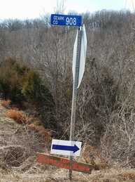
 Unless someone swipes our sign this is at 95 and Long Run
Directions from Gainesville Area
Come north on 5 to 95 on your left. Go 15 miles to Long Run. Turn right and stay on that Gravel Road US Forestry service 147 for 5.8 miles, and it will take you directly to Wolf Junction.
Directions from Springfield:
Take US 65 South to Ozark.
Take the US-65 S/Missouri F exit toward Sparta/South St.
Follow Hwy 14E through Sparta until it forks.
Keep right and continue to MO 125 South to Bradleyville. See below.
Directions from Bradleyville:
Go 1 mile on East 76 to 125, there is a highway maintenance shed there.
Turn right onto 125. Stay on 125 for 10.8 miles.
Turn Left onto the gravel road 149. This is the Glade Top Trail Scenic Byways Road. There is a large brown and white sign there. It is also 125-80(green road sign). Stay on 149 for 5.8 miles. This will take you directly to Wolf Junction.
Directions From Ava, Mo
Starting at the south end of Ava, Junction of Bus. 5, Hwy. 5 and Hwy 76 at the blinking red light.
Go 3.7 Miles on south 5 toward Gainesville.
At Highway A turn Right. Go 3.6 miles.
Turn Left on 409 just after the brown Glade Top Trail Mark Twain National Forest sign. Go 3.2 miles
At the end of the pavement take the upper fork that is to your right (there is a big Mark Twain National Forest marker). You will be on 147, which is a gravel road. Set your odometer from HERE. You will stay on 147 for 11.4 miles until you get to Wolf Junction which is the race headquarters.
At 2.3 miles you come to a ‘t," turn left to stay on 147.
At 3.1 miles. the road forks, keep right to stay on 147.
At 5.5 miles you will pass watershed divide on the right.
At 6.6 miles you will pass Caney picnic area on the left. There are bathrooms available there.
At 8.4 miles follow the Glade Top sign which points you to the left.
At 11.2 miles Willie Lee campsite is on the right.
At 11.4 miles Wolf Junction is straight ahead at the junction of 147 and 149.
It will take you a minimum of 40 minutes to travel from the south edge of Ava to Wolf Junction.